Main menu


You are here

Sea Level

Atlantic City and Miami Beach: two takes on tackling the rising waters

Note: Average seasonal cycle removed from monthly mean sea level Source: National Oceanic and Atmospheric Administration | Graphic: Jan Diehm/The Guardian

IMAGE: Note: Average seasonal cycle removed from monthly mean sea level Source: National Oceanic and Atmospheric Administration | Graphic: Jan Diehm/The Guardian

theguardian.com - March 20th 2017 - Oliver Milman

The Irish Pub near Atlantic City’s famed boardwalk doesn’t have any locks on the doors as it is open 24 hours a day. So when Hurricane Sandy crunched into what was once known as the Las Vegas of the east coast in 2012, some improvisation was needed.

Regular drinkers helped slot a cork board through the frame of the door, wedging it shut and keeping out the surging seawater.

(VIEW COMPLETE ARTICLE)

Country / Region Tags: 
Problem, Solution, SitRep, or ?: 

A Bayesian Network to Predict Vulnerability to Sea-Level Rise: Data Report

pubs.usgs.gov - by Benjamin T. Gutierrez, Nathaniel G. Plant, and E. Robert Thieler - November 2011

Abstract

During the 21st century, sea-level rise is projected to have a wide range of effects on coastal environments, development, and infrastructure. Consequently, there has been an increased focus on developing modeling or other analytical approaches to evaluate potential impacts to inform coastal management. This report provides the data that were used to develop and evaluate the performance of a Bayesian network designed to predict long-term shoreline change due to sea-level rise. The data include local rates of relative sea-level rise, wave height, tide range, geomorphic classification, coastal slope, and shoreline-change rate compiled as part of the U.S. Geological Survey Coastal Vulnerability Index for the U.S. Atlantic coast. In this project, the Bayesian network is used to define relationships among driving forces, geologic constraints, and coastal responses. Using this information, the Bayesian network is used to make probabilistic predictions of shoreline change in response to different future sea-level-rise scenarios.

Country / Region Tags: 
General Topic Tags: 
Problem, Solution, SitRep, or ?: 

Responses to Climate Change - Planning for Changing Sea Levels

corpsclimate.us

More than 8 million people live in areas at risk of coastal flooding. Along the U.S. Atlantic Coast alone, almost 60 percent of the land that is within a meter of sea level is planned for further development, with inadequate information on the potential rates and amount of sea level rise.

Country / Region Tags: 
General Topic Tags: 
Problem, Solution, SitRep, or ?: 

Disastrous Sea Level Rise Is an Issue for Today's Public - Not Next Millennium's


huffingtonpost.com - by Dr. James Hansen - July 27, 2015

. . . 2°C global warming, rather than being a safe "guardrail," is highly dangerous. . . .

. . . My conclusion, based on the total information available, is that continued high emissions would result in multi-meter sea level rise this century and lock in continued ice sheet disintegration such that building cities or rebuilding cities on coast lines would become foolish. . . .

. . . A startling conclusion of our paper is that effects of freshwater release onto the Southern Ocean and North Atlantic are already underway and 1-2 decades sooner in the real world than in the model (Fig. 2). 

(READ COMPLETE ARTICLE)

CLICK HERE - Atmospheric Chemistry and Physics - Earth's energy imbalance and implications

CLICK HERE - Ice Melt, Sea Level Rise and Superstorms: Evidence from Paleoclimate Data, Climate Modeling, and Modern Observations that 2°C Global Warming is Highly Dangerous

OR

Country / Region Tags: 
General Topic Tags: 
Problem, Solution, SitRep, or ?: 

Jamaica Bay Greenway Coalition Meeting -- Saturday Nov. 2, 10:30 am at Ryan Visitor Center Floyd Bennett Field

!!!!!!!!!!!!!!!!!!!!!!!!!!!!!!!!!!!!!!!!!!!!!!!!!!!!!!!!!!


Hello Canarsie,


I hope you are all well. I am happy to invite you to the next Jamaica Bay Greenway Coalition meeting, which will be held on November 2, 10:30 am at the Ryan Visitor's Center. This will be a very special coalition meeting because as Alice Friedman (from NYCDOT Greenways Department) will join us to introduce DOT's Jamaica Bay Greenway Implementation project and planning process. This is an amazing first step to begin to address some of the greenway issues that have been discussed in previous meetings and workshops. Also, during this meeting we wanted to focus sometime to defining our role(s) in this process as well as how we all mutually benefit from coming together.


As was discussed in the last meeting, we ask that you think about the following and come prepared to discuss:


o Your interests & goals for being part of this project & Coalition

o How you feel the Coalition can help your goals

o What you can do to contribute to the Coalition


Meeting / Event Tags: 
Problem, Solution, SitRep, or ?: 

Wednesday, 11/6, join the climate change and vulnerable populations discussion at the Brooklyn Historical Society,

Brooklyn Long Term Recovery Group


FREE This Wednesday, 11/6, join the climate change and vulnerable populations discussion at the Brooklyn Historical Society, 6PM-7:30PM. The focus will be on Red Hook, Sunset Park and Williamsburg.

http://www.marfadialogues.org/participants/center-for-social-inclusion/


http://www.marfadialogues.org/participants/center-for-social-inclusion/


Meeting / Event Tags: 
Country / Region Tags: 
Problem, Solution, SitRep, or ?: 

The Hard Math of Flood Insurance in a Warming World


A man walks through flooded streets in Hoboken, New Jersey, after Superstorm Sandy | Emile Wamsteker/Bloomberg via Getty Images

As subsidized rates of federal flood insurance rise, property owners along the coasts get angry. But we need insurance that reflects the risks of a changing planet

time.com - by Bryan Walsh - October 1, 2013

Thousands of homeowners in flood-prone parts of the country are going to be in for a rude awakening.  On Oct. 1, new changes to the National Flood Insurance Program (NFIP), which offers government-subsidized policies for households and businesses threatened by floods, mean that businesses in flood zones and homes that have been severely or repeatedly flooded will start going up 25% a year until rates reach levels that would reflect the actual risk from flooding. (Higher rates for second or vacation homes went into effect at the start of 2013.) That means that property owners in flood-prone areas who might have once been paying around $500 a year—rates that were well below what the market would charge, given the threat from flooding—will go up by thousands of dollars over the next decade.

Country / Region Tags: 
Problem, Solution, SitRep, or ?: 

Canarsie Community <Light our Way to Recovery> October 29, 2013, Canarsie Park 6:30pm

 Light Our Way To Recovery is a candlelight commemorative gathering of the constituents of the Canarsie community, one of the many disaster impacted communities on the Eastern USA coastline. This event is given in remembrance of those persons who lost their lives as a result of Hurricane Sandy; to honor the people who volunteered and who continue to help; to highlight the need for support for Canarsie disaster victims who continue to struggle to rebuild, recover and survive the emotional maelstrom caused by the life changing events of October 29th 2012. 

Meeting / Event Tags: 
Country / Region Tags: 
Problem, Solution, SitRep, or ?: 

In Canarsie, a Flood Map Is Seen as Long Overdue


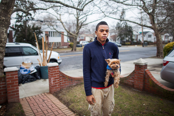
Stefan Leon, 19, whose Canarsie home was flooded by Hurricane Sandy, said of the new flood map, “It’s good for future reference, but it’s too late for what’s already happened."  Michael Nagle for The New York Times

nytimes.com - by Cara Buckley - January 30, 2013

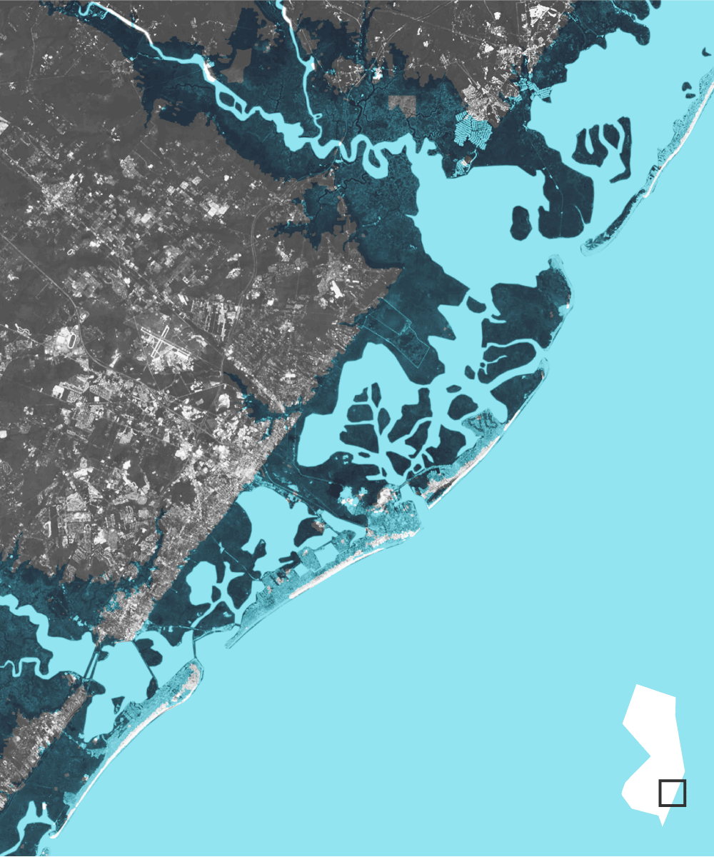
When the federal government introduced new maps this week showing a marked increase in flood-prone areas near New York City’s coast, the general sentiment in Canarsie, Brooklyn — much of which is newly in a flood zone — was, “What took them so long?”

The neighborhood is scant blocks from Jamaica Bay, pancake flat and a stone’s throw from the auspiciously titled Fresh Creek. It’s where, the story goes, local residents once beseeched the city to erect a wall to guard them from a tidal surge. And it’s where, as Hurricane Sandy hit, floodwaters raced through the streets, beat down doors to fill basements and chased inhabitants clutching computers, clothes and rescued pets to upper floors.

(READ COMPLETE ARTICLE)

Country / Region Tags: 
Problem, Solution, SitRep, or ?: 

Pages

Subscribe to Sea Level
howdy folks